West Somerset Railway: Part 1

For reasons unclear, I agreed to walk the West Somerset Railway. I blame my brother, he runs marathons and likes a challenge. So I said yes. It did mean a happy evening plotting the route onto an OS map from the West Somerset Railway website. Such fun.
We put aside a weekend in August to do the walk, it's around 24 miles, so we were going to do it in two halves. The first part, Minehead to Williton, is just around the halfway mark. Getting there early was going to be a hassle as the trains and buses don't start running early enough. So we enlisted Mother, to keep it in the family, to drop us off.
On a bright and breezy August morning we were dropped off on the seafront at Minehead. To our left was the start of the South West Coast Path and right was the Somerset Coast Path. The beaches of Minehead are quite lovely, very sandy. Although the sand there now only dates from 1999. Most of it was washed away in a bad storm in 1990 and 320,000 tonnes of sand had to be imported in 1999 to replace it.
The first part of the walk is along the seafront and isn't terribly inspiring. However, part of the beach is called Madbrain Sands. And this is why I love OS maps, all these fascinating little names and bits of history marked on the map, like the submarine forest further out. It turns out Madbrain Sands is home to the shipwreck of the Bristol Packet from 1808. It was exposed in storms over the winter of 2014/15 and can be seen at low tide.
You can't avoid the massive Skyline Pavilion of Butlin's on your right. It's a big holiday camp, the largest in the Butlin's chain. It was founded in 1962 and is still going strong. As you pass Butlin's the path leaves the paved seafront and goes over the dunes, always nice to walk on sand so early in the proceedings. This follows the edge of the golf course. This is much more pleasant, away from the traffic and only a small chance of being knocked out by a golf ball.
By an outflow pipe, the path heads inland towards the second station, Dunster. On the way, you pass by a magnificent house, The Old Manor. Luckily it's a holiday cottage so you can have a proper nose round online. It's gorgeous, dating from 1400 and Grade II listed. It is where the Constable of Dunster used to live. It even has its own chapel.
Dunster Station reached, hurrah, and I noted that each station has a rather good selection of second hand books as well as loos and a cafe. Very handy. The path follows along the platform and down the other side to reach Sea Lane, which unsurprisingly, took us back to the beach. The sunken wetland to the left is said to be the old harbour for Dunster and was used until it silted up. The village of Dunster is still a good 20 minute walk from the station though.
The path here joins a cycle path linking Dunster Beach with Blue Anchor, well, sort of. The route is fine until nearing Blue Anchor but because of land ownership issues the cycle path abruptly finishes and becomes pebbles, not so easy to ride on. Especially as the 'path' joins the road via a set of steps. Very odd.
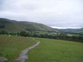
Talking of odd, here is Blue Anchor. It seems to be mainly a holiday park and a shingle beach. But at least if you needed an ice cream you'd be okay. By Home Farm campsite we turned off the seafront and walked past a rather tempting pub out into the countryside. This is a rather lovely part of the walk, not least because of the friendly pigs that came running over to say hello. The walk heads through farmland with beautiful ancient oak trees and wheat fields. We passed Binham Farm, a gorgeous old Jacobean house with a topiary front garden. By this time the temperature was beginning to rise and without the breeze from the sea it started getting humid. Time for lunch.
The chosen spot was the churchyard of St Andrew's in Old Cleeve. There was a lovely rowan tree with out name on it.
Feeling refreshed after lunch we tackled the steepest part of the walk, Monks Path. This lane is part of an old pilgrimage route between Cleeve Abbey and a church in Blue Anchor that has since fallen into the sea. There are the remains of old crosses by the side of the lane. The path veers off to the right and down some steep steps into Washford. The lane goes under the railway and then by the primary school, turning left on to the Mineral Line. By the way, loving the pencil fence at the school.
The Mineral Line is an old railway that ran from the iron ore mines in the Brendan Hills to Watchet where it was loaded on to boats and sailed over to Wales for smelting. The path follows the steam railway and the Washford River. This is where we wish we'd bought lilos in Minehead and then floated into Watchet.
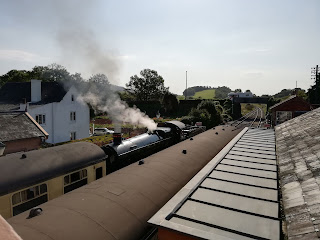
Watchet is a funny old town and the route doesn't really take you into the centre. Plus this part of the walk is more built up following roads and suburbun streets. These lead through new estates in to Williton. By this time we had done just over 11 miles and it was rather hot and sticky. As we waited for the train I had a peruse of the second hand books for sale, there were plenty of VHS on trains for the avid fan. Also, the photo pf the beautiful knot garden is taken at the station. We took the train back to Bishop's Lydeard and part two will begin from Williton.
Feeling refreshed after lunch we tackled the steepest part of the walk, Monks Path. This lane is part of an old pilgrimage route between Cleeve Abbey and a church in Blue Anchor that has since fallen into the sea. There are the remains of old crosses by the side of the lane. The path veers off to the right and down some steep steps into Washford. The lane goes under the railway and then by the primary school, turning left on to the Mineral Line. By the way, loving the pencil fence at the school.
The Mineral Line is an old railway that ran from the iron ore mines in the Brendan Hills to Watchet where it was loaded on to boats and sailed over to Wales for smelting. The path follows the steam railway and the Washford River. This is where we wish we'd bought lilos in Minehead and then floated into Watchet.
Watchet is a funny old town and the route doesn't really take you into the centre. Plus this part of the walk is more built up following roads and suburbun streets. These lead through new estates in to Williton. By this time we had done just over 11 miles and it was rather hot and sticky. As we waited for the train I had a peruse of the second hand books for sale, there were plenty of VHS on trains for the avid fan. Also, the photo pf the beautiful knot garden is taken at the station. We took the train back to Bishop's Lydeard and part two will begin from Williton.
Comments
Post a Comment